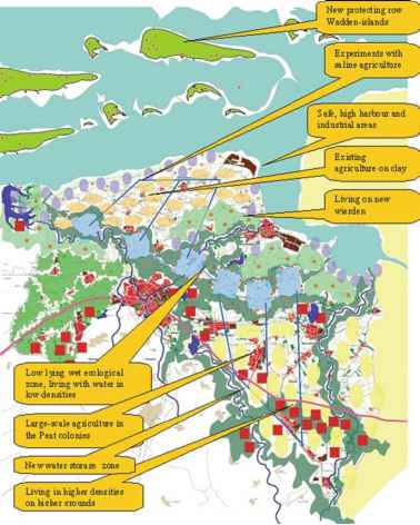
Idea Map Climate Adapted Groningen
Climate analyses (KNMI, 2GG6; Alterra et al. 2GGS; Roggema, 2GG7a) and the effects on existing functions (MNP, 2GG5) are integrated in an Idea-map for an
-

- Fig. 2.21 Idea-map climate adapted Groningen (Source: Roggema, 2007a)
adaptive Groningen (Fig. 2.21) (Roggema, 2007a). This map represents a future vision on a climate proof Groningen with spatial measures. The map was developed by the spatial adaptation design team within the province of Groningen and was used in discussions about the new regional plan for Groningen. The following principles are part of the Idea-map:
1. In the lowest parts of the province, water is stored. Even in dryer periods, water is kept in this lowest area and creates wet circumstances in a natural way. This enables nature to develop a robust ecological connection between the Dollard and Lauwers Lake. Existing brooks discharge their water from the higher grounds on the Drenthe plateau. In the ecological zone existing as well as colonising species are able to find suitable habitats;
2. The water storage areas also function as the water resource to provide agriculture with enough water of good quality. This is especially relevant in the Peat Colonies, where干旱有最大的影响。水可以运输ed towards the agricultural ground by making use of the existing canal system in the Colonies. The availability of water is essential for the potato starch production in the area. The supply with clean water is necessary from a quantitative point of view, but is also needed for a qualitative reason. In the 'dry' KNMI-scenarios, the groundwater level will drop and might even become saline. Addition of sweet water prevents the available water for agricultural use from becoming useless; (Haren et al., 2007)
3. The salinity along the northern coastal zone increases, due to the sea level rise and the increased salty seepage. This makes this area suitable for saline agriculture andaquacultures;
4. Near Lauwers Lake, Dollard and around Delfzijl space is created to inundate water from the sea into 'climate buffers' (Bureau Stroming, 2006). A brackish environment emerges. The combination of salt and sweet water makes it possible to generate energy in an osmosis plant;
5. In front of the Northern Coast new Wadden Islands are created to protect the province, to develop nature and to provide development locations for living and recreation.
6. The safest parts in the province to create living areas are found in higher elevated areas: Around Leek and the city of Groningen and in the southern part of the Peat Colonies and Westerwolde.
Continue reading here:Dutch Weak Links
Was this article helpful?
