Thermohaline circulation and climate
Variations in formation andcirculation of ocean watermay cause some of the thousands of years to decadal scale variations in climate. Cold water forms in the Arctic and Weddell Seas. This cold salty water is denser than other water in the ocean, so it sinks to the bottom and gets ponded behind seafloor topographic ridges, periodically spilling over into other parts of the oceans. The formation and redistribution of North Atlantic cold bottom water accounts for about 30 percent of thesolar energybudget input to the Arctic Ocean every year. Eventually, this cold bottom water works its way to the Indian and Pacific Oceans where it upwells, gets heated, and returns to the North Atlantic.Thermohaline circulation isthe vertical mixing of seawater driven by density differences caused by variations in temperature and salinity. Variations
-

- Map of the world's oceans showing main warm and cold currents driven by thermohaline circulation

in temperature and salinity are found in waters that occupy different ocean basins and those found at different levels in the water column. When thedensity of waterat one level is greater than or equal to that below that level, the water column becomes unstable and the denser water sinks, displacing the deeper, less-dense waters below. When the dense water reaches the level at which it is stable it tends to spread out laterally and form a thin sheet, forming intricately stratified ocean waters. Thermohaline circulation is the main mechanism responsible for the movement of water out of cold polar regions and exerts a strong influence on global climate. The upward movement of water in other regions balances the sinking of dense cold water, and these upwelling regions typically bring deep water, rich in nutrients, to the surface. Thus, regions of intense biological activity are often associated with upwelling regions.
The coldest water on the planet is formed in the polar regions, with large quantities of cold water originating off the coast of Greenland and in the Weddell Sea of Antarctica. The planet's saltiest ocean water is found in the Atlantic Ocean, and this is moved northward by the Gulf Stream. As this water moves near Greenland it is cooled and then sinks to flow as a deepcold currentalong the bottom of the western North Atlantic. The cold water of the Weddell Sea is the densest on the planet, where surface waters are cooled to -35.4°F (-1.9°C), then sink to form a cold current that moves around Antarctica. Some of this deep cold water moves northward into all three major ocean basins, mixing with other waters and warming slightly. Most of thesedeep ocean currentsmove at one to four inches (a few to 10 cm) per second.
Presently, the age of bottom water in the equatorial Pacific is 1,600 years, and in the Atlantic it is 350 years. Glacial stages in the North Atlantic have been correlated with the presence of older cold bottom waters, approximately twice the age of the water today. This suggests that the thermohaline circulation system was only half as effective atrecyclingwater during recent glacial stages, with less cold bottom water being produced during the glacial periods. These changes in production of cold bottom water may in turn be driven by changes in the North American ice sheet, perhaps itself driven by 23,000 year orbital (Milankovitch) cycles. It is thought that a growth in the ice sheet would cause the polar front to shift southward, decreasing the inflow of cold saline surface water into the system required for efficient thermohaline circulation. Several periods of glaciation in the past 14,500 years (known as the Dryas) are thought to have been caused by sudden, even catastrophic, injections into the North Atlantic ofglacial meltwaterthat would decrease the salinity and hence density of the surface water. This in turn would prohibit the surface water from sinking to the deep ocean, inducing another glacial interval.
Shorter-term decadal variations in climate in the past million years are indicated by so-called Heinrich Events, defined as specific intervals in the sedimentary record showing ice-rafted debris in the North Atlantic. These periods of exceptionally large iceberg discharges reflect decadal scale sea surface andatmospheric coolingrelated to thickening of the North American ice sheet followed by ice stream surges. These events flood the surface waters with low-salinity fresh water, leading to a decrease in flux to the cold bottom waters, and hence a short period global cooling.
Changes in the thermohaline circulation rigor have also been related to other global climate changes.Droughtsin the Sahel and elsewhere are correlated with periods of ineffective or reduced thermohaline circulation, because this reduces the amount of water drawn into the
North Atlantic, in turn cooling surface waters and reducing the amount of evaporation. Reduced thermohaline circulation also reduces the amount of water that upwells in the equatorial regions, in turn decreasing the amount of moisture transferred to the atmosphere, reducing precipitation at high latitudes.
Atmospheric levels二氧化碳等温室气体和大气temperatures show a correlation to variations in the thermohaline circulation patterns and production of cold bottom waters. CO2 is dissolved in warm surface water and transported to cold surface water, which acts as a sink for the CO2. During times of decreased flow from cold, high-latitude surface water to the deep ocean reservoir, CO2 can build up in the cold polar waters, removing it from the atmosphere and decreasing global temperatures. In contrast, when the thermohaline circulation is vigorous, cold oxygen-rich surface waters downwell, and dissolve buried CO2 and even carbonates, releasing this CO2 to the atmosphere and increasing global temperatures.
The present day ice sheet in Antarctica grew in the middle Miocene, related to active thermohaline circulation that caused prolific upwell-ing of warm water that put more moisture in the atmosphere, falling as snow on the cold southern continent. The growth of the southern ice sheet increased the global atmospheric temperature gradients, which in turn increased the desertification of mid-latitude continental regions. The increased temperature gradient also induced stronger oceanic circulation, including upwelling and removal of CO2 from the atmosphere, lowering global temperatures and bringing on late Neogene glaciations.
Ocean bottom topography exerts a strong influence on densebottom currents. Ridges deflect currents from one part of a basin to another and may restrict access to other regions, whereas trenches and deeps may focus flow from one region to another.
El Niño and the Southern Oscillation (ENSO)
El Niño-Southern Oscillation is the name given to one of the better-known variations in globalatmospheric circulation patterns. Global oceanic and atmospheric circulation patterns undergo frequent shifts that affect large parts of the globe, particularly thosearid and semi-aridparts affected byHadley Cellcirculation. It is now understood that fluctuations in global circulation can account forbetray雷竞技 , including the dust bowl days of the 1930s in the midwestern United States. Similar global climate fluctuations may explain the drought, famine, and desertification of parts of the Sahel and the greatfaminesof Ethiopia and Sudan in the 1970s and 1980s.
The secondaryair circulationphenomenon known as the El Nino-Southern Oscillation can also have profound influences on the development of drought conditions and desertification of stressed lands. Hadley Cells migrate north and south with summer and winter, shifting the locations of the most intense heating. There are several zonal oceanic-
Normal conditions
Normal conditions
Cold water
Upwelling
Reduced upwelling
O Infobase Publishing
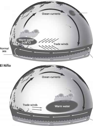
Schematic diagramsof the different patterns of ocean and air circulation over the Pacific associated with El Niño and normal conditions
Cold water
Upwelling
O Infobase Publishing
Reduced upwelling
Schematic diagrams of the different patterns of ocean and air circulation over the Pacific associated with El Niño and normal conditions atmospheric feedback systems that influence global climate, but the most influential is that of the Australasian system. In normal Northern Hemisphere summers, the location of the most intense heating in Australasia shifts from equatorial regions to the Indian subcontinent along with the start of theIndian monsoon. Air is drawn onto the subcontinent, where it rises and moves outward to Africa and the central Pacific. In Northern Hemisphere winters, the location of this intense heating shifts to Indonesia and Australia, where an intense low-pressure system develops over this mainly maritime region. Air is sucked in and moves upward and flows back out at tropospheric levels to the east Pacific. High pressure develops off thecoast of Peruin both situations, because coldupwelling wateroff the coast here causes the air to cool, inducing atmospheric downwelling. The pressure gradient set up causeseasterly trade windsto blow from the coast of Peru across the Pacific to the region of heating, causing warm water to pile up in the Coral Sea off the northeast coast of Australia. This also causes sea level to be slightly depressed off the coast of Peru, and more cold water upwells from below to replace the lost water. This positive feedback mechanism is rather stable—it enhances the global circulation, as more cold water upwelling off Peru induces more atmospheric downwelling, and more warm water piling up in Indonesia and off the coast of Australia causes atmospheric upwelling in this region.
This stable linked atmospheric and oceanic circulation breaks down and becomes unstable every two to seven years, probably from some inherentchaotic behaviorin the system. At these times, the Indonesian-Australian heating center migrates eastward, and the build-up of warm water in the western Pacific is no longer held back by winds blowing westward across the Pacific. This causes the elevated warm water mass to collapse and move eastward across the Pacific, where it typically appears off the coast of Peru by the end of December. The El Niño-Southern Oscillation (ENSO) events occur when this warming is particularly strong, with temperatures increasing by 40-43°F (22-24°C) and remaining high for several months. This phenomenon is also associated with a reversal of the atmospheric circulation around the Pacific such that the dry downwelling air is located over Australia and Indonesia, and the warm upwelling air is located over the eastern Pacific andwestern South America.
The arrival of El Niño is not good news in Peru, since it causes the normally cold upwelling and nutrient rich water to sink to great depths, and the fish either must migrate to better feeding locations or die. The
-
 southeast of Lima in the Andes. The town was devastated by mud and rock flows from the Sacsara River, which overflowed from heavy rains associated with El Niño, killing 17 people and leaving 1,000 homeless. (AP)")
- View of the remains of the town of Santa Teresa, Peru, 310 miles (500 km) southeast of Lima in the Andes. The town was devastated by mud and rock flows from the Sacsara River, which overflowed from heavy rains associated with El Niño, killing 17 people and leaving 1,000 homeless. (AP)
 southeast of Lima in the Andes. The town was devastated by mud and rock flows from the Sacsara River, which overflowed from heavy rains associated with El Niño, killing 17 people and leaving 1,000 homeless. (AP)")
fishing industry collapses at these times, as does thefertilizerindustry that relies on the bird guano normally produced by birds (that eat fish and anchovies) that also die during El Niño events. The normally cold dry air is replaced with warm moist air and the normally dry or desert regions ofcoastal Perureceive torrential rains with associated floods, landslides, death, and destruction. Shoreline erosion is accelerated in El Niño events, because the warm water mass that moved in from across the Pacific raises sea levels by 4-25 inches (10-60 cm), enough to cause significant damage.
The end of ENSO events also leads to abnormal conditions, in that they seem to turn on the "normal" type of circulation in a much stronger way than is normal. The cold upwelling water returns off Peru with such a ferocity that it may move northward, flooding a 1-2° band around the equator in the central Pacific ocean with water that is as cold as 68°F (20° C). This phenomenon is known as La Niña ("the girl" in Spanish).
The alternation between ENSO, La Niña, and normal ocean-atmospheric circulation has profound effects on global climate and the migration of different climate belts on yearly to decadal time scales, and is thought to account for about a third of all the variability inglobal rainfall. ENSO events may cause flooding in the western Andes and southern
California and alack of rainfallin other parts of South America including Venezuela, northeastern Brazil, and southern Peru. It may change the climate, causingdroughts in Africa, Indonesia, India, and Australia and is thought to have caused the failure of the Indian monsoon in 1899 that resulted in regional famine with the deaths of millions of people. Recently, the seven-year cycle of floods on the Nile has been linked to ENSO events, and famine and desertification in the Sahel, Ethiopia, and Sudan can be attributed to these changes in global circulation as well.
Continue reading here:Global warming holes
Was this article helpful?
Recommended Programs


Readers' Questions
-
vala1 day ago
- Reply
-
adelia rossi4 months ago
- Reply
-
Eric4 months ago
- Reply
-
myrtle4 months ago
- Reply
-
matilda4 months ago
- Reply